Bow-Yoho Ski Traverse
Skiing the Bow-Yoho Traverse – with Emerald Lake exit
The Bow – Yoho traverse is a good alternative for those looking at doing something other than the Classic Wapta traverse. This interesting ski traverse runs south-east starting at Bow Lake near Num-Ti-Jah lodge (“Icefield Parkway” – Highway 93N) and finishes either at Emerald Lake Lodge or near the Cathedral Mountain Chalets (Tatakkaw Falls parking lot) both located on Trans Canda highway near the town of Field, BC in Yoho National Park.
For our trip we chose to ski out via Iceline trail & Yoho Pass ending up at Emerald lake.
Starting On April 20th, 2014 Alicja, Sarah and I skied 42 km (26 miles) which included ~2000 m (6,600 ft.) of climbing and of ~2200 m (7,200 ft) descending. We spent the first night at Bow Hut and our second night at Stanley Mitchell Hut both of which are managed by Alpine Club of Canada (ACC)
Day 1: Bow Lake – Bow Hut
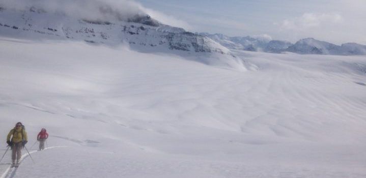
Crossing Bow Lake shortly after leaving Num-Ti-Jah lodge parking lot at 11 am.

Although majority of skiers take this approach to reach the Wapta Icefield (this being the easiest and fastest route compared to other approaches), this route presents significant mountain hazards in the winter as all kinds of avalanche terrain exists high above the route.
Skinning up through the Canyon “mouse trap” which is definitely an avalanche terrain trap. This approach should only be considered when avalanche conditions permit.

Traveling at a fairly leisurely pace we arrived at Bow Hut around 2 pm, 3 hours after departure. Bow Hut (located at 535300 E 5720500 N, at 2375m, 7,792 ft) is the largest hut on the Wapta Icefield and is an excellent base for climbing many nearby peaks. Because of this the hut tends to be quite busy especially on long weekends. Saturday night the hut was at maximum capacity of 30 people and during our stay Sunday night we were at about 20 people.
One of the popular climbing objectives – St. Nicholas as seen from Bow Hut. You can see this peak right from the Icefields Parkway (HWY 93N)

Skiers on Bow Glacier enjoying 10cm’s of relatively fresh storm snow

Looking North East from Bow Hut, you can see Observation Peak on the other side of Highway 93N. Crowfoot Mountain is on the right.

Day 2: Bow Hut – Stanley Mitchel Hut
This is the first leg of the Yoho Traverse beginning at Bow hut and ending at the Stanley Mitchell hut 20 km (12.4 miles) away. Most parties chose to camp on Glacier Des Poilus or near Mt. Collie splitting this day into two sections. We opted to do it in a day which saved us from carrying a tent, sleeping mats, stove, pots and what ever else we would need for winter camping. Lighter packs allowed for faster travel.
The ACC has plans to build a new hut on or just above Glacier Des Poilus. This hut would make an outstanding addition and a great hut-to-hut traverse. The proposed hut’s location is UTM GR 530000 E 5714800 N, at 2585 m (8,481 ft.)
Alicja and Sarah in front of Bow Hut, just before our 6:50 am departure for Stanley Mitchell Hut. We wanted to get an early start taking advantage of a fast travel conditions thanks to a decent overnight freeze.

On Bow Glacier. “The Onion” on the left and Crowfoot Mountain on the right.

On Bow glacier near the high point on continental divide (2700m). Mt. Rhondda is on the left with Ayesha Glacier in front of it.

Skiing towards the high point on the SE side of Mt. Collie just above the crevasses. Mt. Rohondda is behind us. This section would be very challenging to navigate in a whiteout. With great visibility we were able to negotiate the exposed crevasses with ease. Snow pack on the glacier ranged from 185 cm near the continental divide to over 300 cm just below the crevasses and up at at the high point near Mt. Collie (2920 m, 9580 ft.).

Alicja descending down to Des Poilus Glacier. This is a steep slope which requires good visibility and snow stability and we were blessed with both.

Looking back up at our descent line from Mt. Collie high point (Mt. Collie shoulder).

Looking towards north side of Isolated Col. Given good snow stability we decided to go over Isolated Col. ascending the right to left leaning ramp.

Another option to get over to the other side would be to go over Whaleback and then travel over lower angle slopes, then you stick to the thick forest on the decent to the other side.
At the bottom of Des Poilus Glacier.

At the top of Isolated Col (loc:529700 E 5710400 N, 2570m, 8,432 ft). “Vice President” directly behind Alicja and “The President” on the right.

Just before skiing down south side of Isolated Col. This slope is steeper than it looks at the top. To get down to the hut we continued down the valley then descended steeply through the trees.

We arrived at the Stanley Mitchell hut, located at 530300 E 5708500 N, at 2050m (6,725 ft) on the edge of a meadow along the Little Yoho river at 2 pm, exactly 7 hours after departing Bow Hut. Having good travel conditions with ski penetration of about 5-10cm and relatively good visibility throughout the day really helped us complete this leg in relatively short time leaving us with tons of time for rest and relaxing before our final leg of the traverse the following day. We spend a nice night in the company of two other groups (10 skiers in total).
Day 3: Stanley Mitchell Hut – Emerald Lake Lodge (via Iceline / Yoho Pass)
For the final leg of the Yoho ski traverse we chose to ski out via the Iceline trail & Yoho Pass ending up at Emerald lake. The Iceline travels over high terrain / bench above Yoho valley and below the Vice President / President Range. Steep moraine slopes and significant hazard exists from large slopes and cornices above and this exit variation was only possible because of the relatively low avalanche danger. The other exit option would have been the normal Yoho Valley Route which descends a headwall into the valley and then follows the Takakkaw Falls road.
Looking west from Stanley Mitchell Hut. The sombrero is part of the hut collection!

Stanley Mitchell Hut just before our 9 am departure.

South side of Isolated Peak. Isolated Col which we skied down the day before is on the right side.

Negotiating Emerald Glacier moraines.

Just before descending down to Yoho Pass / Lake. We had to navigate around cliff bands through thick forest in very challenging (border line isothermic) snow conditions.

2:30 pm finish at Emerald Lake Lodge. Yoho Pass is the low point in the ridge line. It took us 5.5 hours to ski this final leg of the traverse. Now all was left is to fetch our other vehicle from Num-Ti-Jah lodge parking near Bow Lake and to celebrate over burgers and beer at the Lake Louise Hostel.

Distances / elevation gain & loss for each section
Bow Lake – Bow Hut
6.5 km (4 miles) / 525 m elevation gain
Bow Hut – Stanley Mitchell Hut (Yoho Traverse)
20 km (12.4 miles) / 1050 m elevation gain, 1170 m elevation loss
Stanley Mitchell Hut – Emerald Lake Lodge (via Iceline / Yoho Pass)
15 km (9.3 miles) / 450 m elevation gain, 1050 elevation loss
Total distances and elevations for this traverse
41.5 km (26 miles), 2025 m (6,600 ft) of climbing and 2220 m (7300 ft) )of descending
When to go
Since several slopes present significant avalanche potential and you travel through complex terrain, you need a period of good snow stability and good weather. Although this trip is possible mid winter, spring is the best time to go since the days are longer and snow stability tends to be better.
If you chose to do this traverse in late spring you might encounter isothermic snow conditions at lower elevation (as you are approaching the ice field or exiting through the Yoho Valley) so watch the freezing levels and overnight temperatures before departing.
Planning Resources
- Summits & Icefields 1 Book on Amazon
- Where to buy Summits & Icefields Map (retailers)
- Avalanche Bulletins
- Alpine Club of Canda (ACC) Hut Reservations
- Outdoor Gear price checker (easily find gear on sale)
Bow – Yoho ski traverse photo gallery


What’s your favorite ski summit or ski tour?
Author: Mike Blarowski
Read more trip reports
- REI Used Gear Garage Sale - October 23, 2017
- Katadyn BeFree Water Filter Giveaway - September 25, 2017
- Banff Highline Backpacking Trip - July 27, 2016
We write rarely, but only the best content.
