Hiking in Waterton: The Carthew-Alderson Trail
About Hiking in Waterton
There are so many beautiful places to hike Waterton, and we have been there many times. There are over 255 km of hiking trails, and several mountains where you can easily hike or scramble to the summit. The variety of trails is endless, including short hikes, half day hikes, full day hikes, and one multi-day option

Think long, sweeping ridges, big panoramas, endless alpine walking, big skies and big winds. It’s easy to get romantic about the place, and gives great mountain photography including scenic panoramas, wildflowers, and wildlife, too.
There is a big population of grizzly and black bear in the park, and you’ll often find them near roads or at the townsite. When you do, know that Parks Canada wardens are close at hand to protect these animals, and in the case of a bear in town, make sure to chase them away.
We witnessed this first hand. A family of black bears made their way into town, and the wardens were hard at work to chase them away. The bears took refuge near the local ice cream shop, where a few of them climbed a tree!

Waterton Lakes National Peace Park straddles the Alberta border near our friendly American neighbours in the state of Montana. The American side of the park is the very famous Glacier National Park, which, as it’s name suggests boasts high alpine country and is home to many glaciers, unlike Waterton – where no glaciers remain in the park. The mountain range is very old, and as these mountain ranges go, they are crumbling. Old mountains means weathered mountains, which means lots of loose rock, scree, talus and gentle alpine slopes.
Where the mountains meet the Prairie
Created in 1895, a 140 sq. km area was set aside, and was Canada’s fourth national park, and the smallest in the Canadian Rockies. The park’s size has varied through the years but is now 505 sq. km. The Waterton-Glacier International peace park was created in 1932 as a symbol of peace and goodwill between the US and Canada.

The area represents some of the most ancient mountains in the Rocky Mountain massif. The landscape is shaped by wind, fire and flooding, and harbours a rich variety of plants and wildlife. The park is part of the “Crown of the Continent:” a place with diverse ecology. The ecosystem is also one of the narrowest places in the Rocky mountain chain, making it a pinch point of the crucial north-south wildlife corridor.
The place is full of bears, too, and you’ll likely see them on the Red Rocks Parkway or near middle waterton lake, grazing lazily on the grassy slopes. It is one of the last places in North America where grizzly bears graze on commonly range into the edges of their former grassland territory.

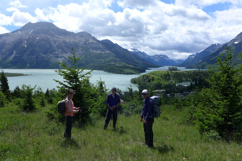
We have done several trips to Waterton, but the last one we hiked and climbed Mt. Bertha (through Bertha Lake), The Carthew-Alderson trail and Mount Crandell.
The Carthew-Alderson Trail in early season
The Carthew-Alderson trail is one of the premier hikes in Waterton. It is well graded, maintained and offers the most amazing panoramic views of old, shaley mountain passes, snowy, steep peaks, alpine lakes and prairie, not to mention the diverse flora and fauna along the trail. Our trip was earlier in the season than usual. Generally, we head to Waterton in September once the nights are cooler, there are no bugs, and all the snow is gone in the alpine. This is also a time of feeding frenzy for the bears, so we have seen a lot of bears this time of year too.

The Carthew-Alderson trail goes up to the high point of 2310m, at Carthew Ridge. This pass separates Mt. Carthew and Mt. Alderson. The trail is 20 km and is generally hiked in one direction, usually from Cameron Lake to the Waterton townsite.
To do this you can take a hiker’s shuttle in the Cameron Lakes trailhead which departs at 8:30 daily in the high season and at 9 am after September 3. It currently costs about $13.50. From Cameron lakes you gain 650 m in elevation and loose 1015 m. Hence if you hike it in the opposite direction, from the townsite to Cameron lakes, you will gain more elevation, which is why the trail is typically done in the other direction. Also, you don’t have to be worried about how to get back to town from Cameron Lakes when you finish the hike.

This one is often rated as Waterton’s number one hike. The trail is excellent, well maintained and well graded. The vistas are stunning. The wind whips through Carthew ridge and is truly something to behold. The narrow mountain pass creates a venturi, which funnels wind through to an increasing intensity. The pass is very barren, and the wind makes it tough to hang out for long! People have actually gotten blown off this ridge. The view gives way to sweeping mountain passes dotted with lakes (the Carthew lakes) and ends with prairie in the distance.

Budget about 6-7 hours for the hike. If you go the other way, it will take you a bit longer as you will gain more elevation than you will loose.
Carthew lakes are surrounded by thick, twisted spruce not more than 3 m tall. Lower down in the valley, we have the larger Alderson lake with a beautiful backcountry campsite on it’s northern shore, and is surrounded by the 700 meter towering rock walls of Mount Alderson. The campground here is the only one on the trail.

We hiked the trail from Waterton Townsite to the Carthew Pass and back because the trail was covered in deep snow on the other side of the pass. We gained over 1000 m in elevation over 22 km. It took us a total of 6 hours. The trail was perfect and dry all the way up to Alderson lake, and from there we began encountering lingering snow patches. Above the lake there was more and more snow up until we got to the second (higher) Carthew lake, which was completely snow walking all the way to the pass. As usual, the wind was strong through the pass and the visibility low.

Tips for hiking the Carthew-Alderson trail
- Hike the trail from Cameron Lake to the Townsite, taking the hiker’s shuttle in the morning, or simply hitchhike back to your car
- Bring a wind jacket! The wind simply screams at the top of the pass
- Don’t forget your camera, the views are outstanding.
Below is a summary of most of the hikes in the Park. Stay tuned for more trip reports from Waterton.
| Length | Trail | Trailhead | Distance (return) |
Time (return) |
Elevation Gain |
| Short Hikes and Strolls | Townsite | Townsite loop | 3.2 km loop (2 mi) |
1 hour | minimal |
| Emerald Bay Loop | Townsite | 4 km loop (2.4 mi) |
1.5 hours | minimal | |
| Prince of Wales | Emerald Bay | 2.0 km loop (1.2 mi) |
45 minutes | minimal | |
| Linnet Lake *barrier free access |
Dock area across from Warden Office | 1.0 km loop (0.6 mi) |
20 minutes | minimal | |
| Cameron Lakeshore | Cameron Lake | 3.2 km (2 mi) |
1 hour | minimal | |
| Akamina Lake | Cameron Lake | 1.0 km (0.6 mi) |
30 minutes | minimal | |
| Red Rock Canyon *hardened surface |
Red Rock Canyon | 0.7 km loop (0.4 mi) |
20 minutes | minimal | |
| Blakiston Falls | Red Rock Canyon | 2.0 km (1.2 mi) |
45 minutes | minimal | |
| Crandell Lake | Crandell Campground | 4.0 km (2.4 mi) |
1.5 hours | 150 m (492′) |
|
| Crandell Lake | Akamina Parkway | 2.4 km (1.5 mi) |
1 hour | 100 m (328′ ) |
|
| Belly River | Belly River Campground | 5.8 km (3.6 mi) |
2 hours | minimal | |
| Lower Bertha Falls | Townsite | 5.6 km (3.4 mi) |
1.5 hours | 150 m (492′) |
|
| Bears Hump | Visitor Centre | 2.8 km (1.7 mi) |
1 hour | 200 m (656′) |
|
| Half Day Hikes | Forum Lake, BC | Akamina Parkway | 8.0 km (4.9 mi) |
3 hours | 300 m (984′) |
| Wall Lake, BC | Akamina Parkway | 11.2 km (7 mi) |
4 hours | 165 m (541′) |
|
| Summit Lake | Cameron Lake | 8.0 km (4.9 mi) |
3 hours | 305 m (1000′) |
|
| Lineham Falls | Akamina Parkway | 8.4 km (5.2 mi) |
3.5 hours | 200 m (656′) |
|
| Lower Rowe Lake | Akamina Parkway | 8.0 km (4.9 mi) |
3 hours | 250 m (820′) |
|
| Rowe Meadow | Akamina Parkway | 10.4 km (6.5 mi) |
4 hours | 350 m (1148′) |
|
| Upper Rowe Lake | Akamina Parkway | 12.6 km (7.8 mi) |
5 hours | 500 m (1640′) |
|
| Bertha Lake | Townsite | 11.4 km (7.1 mi) |
4.5 hours | 500 m (1640′) |
|
| Snowshoe | Red Rock Canyon | 16.4 km (10.2 mi) |
5 hours | 150 m (492′) |
|
| Goat Lake | Red Rock Canyon | 12.6 km (7.8 mi) |
5 hours | 400 m (1312′) |
|
| Full Day Hikes | Lakeshore Trail | Waterton Townsite-cam return by boat | 13 km (one way) (8 mi) |
3-4 hours | 125 m (410′) |
| Horseshoe Basin | Bison Paddock | 21.3 km (13.2 mi) |
5-7 hours | 350 m (1148′) |
|
| Wishbone | Chief Mountain Hwy. | 21 km (13 mi) |
6-8 hours | 50 m (164′) |
|
| Crandell loop | access from Akamina and Red Rock Parkways |
20.6 km (8.1 mi) |
6-7 hours | 200 m (656′) |
|
| Crypt Lake | Crypt Landing | 17.2 km (10.7 mi) |
6-8 hours | 700 m (2297′) |
|
| Carthew-Alderson *Requires transportation to, or back to, trailhead |
Cameron Lake or Cameron falls |
18 km one way (11.1 mi) |
6-8 hours | 650 m (2132′) |
|
| Blakiston Valley | Red Rock Canyon | 20.2 km (12.6 mi) |
5-7 hours | 350 m (1148′) |
|
| Twin Lakes | Red Rock Canyon | 22.8 km (14.2 mi) |
7-9 hours | 300 m (984′) |
|
| Avion Lakes | Red Rock Parkway | 22.6 km (14 mi) |
7-9 hours | 600 m (1969′) |
|
| Multi-Day Hike | Tamarack Trail | Akamina Parkway – Red Rock Canyon *requires transportation to, or back to, trailhead |
31.6 km (19.6 mi) |
2 days | 600 m (1969′) |


- How to experience the world while isolated at home - April 21, 2020
- How to prevent and treat hypothermia - February 21, 2019
- How to layer with your down jacket - November 28, 2018
We write rarely, but only the best content.
