Backpacking the Rockwall Trail in Kootenay National Park
The Rockwall trail is one of the premier backpacking trails in British Columbia, and has received some extensive coverage in the press this year for good reason. The variety of scenery, wildflowers, views of cascading glaciers landing in bright blue alpine tarns and jagged peaks, numerous mountain passes make the trip unforgettable. This trail travels through some of the most beautiful and dramatic scenery out there.
The main draw of the trail is the spectacular hiking that takes you over four passes, the highest over Numa Pass at 2300 meters.

The trail is very distinct and easy to follow, providing there is no snow obscuring it. There are junctions which are clearly signed showing directions and distances. Five campsites are found along the way, each deserving a night to visit, and there are rangers cabins at Helmet Falls, Floe Lake, and near the junction towards Wolverine Pass.

Logistics
The trail can be done either North to South, or South to North. If you start from the South, you’ll start at Floe Lake trailhead, and hike out at Paint Pots trailhead. Most parties opt to start at Floe, and spend their last night at Helmet Falls. We hiked the trail from North to South.
Since the hike is one way and not a loop, you will need two cars parked at either end. If you only have one vehicle it’s very likely that you can get a tourist or another hiker to drop you off at your car. Both Floe Lake Trailhead, and especially Paint Pots Trailhead are very busy.
Need accommodations before or after your trip?
Lake Louise Hotel Deals Finder
Each campground has a large availability of bear lockers, so there is no need to hang up your food on trees or poles, and the lockers keep everything nice and dry from the rain. There are many black and grizzly bears in this area of the Park, though the high traffic of hikers, especially if you’re hiking in a big group, makes a sighting rare. Nervous about camping in bear country? Read our tips on bear safety.

Fees
There are no fees to hike the trail, however, you must pay for your backcountry campsites, which were $9.80 per night (2015 rates). Plus you will need to purchase a backcountry pass. Read the Parks Canada guide for information on how to book your spots on the trail. You must call the Parks office to book; online reservations are not available at this time.
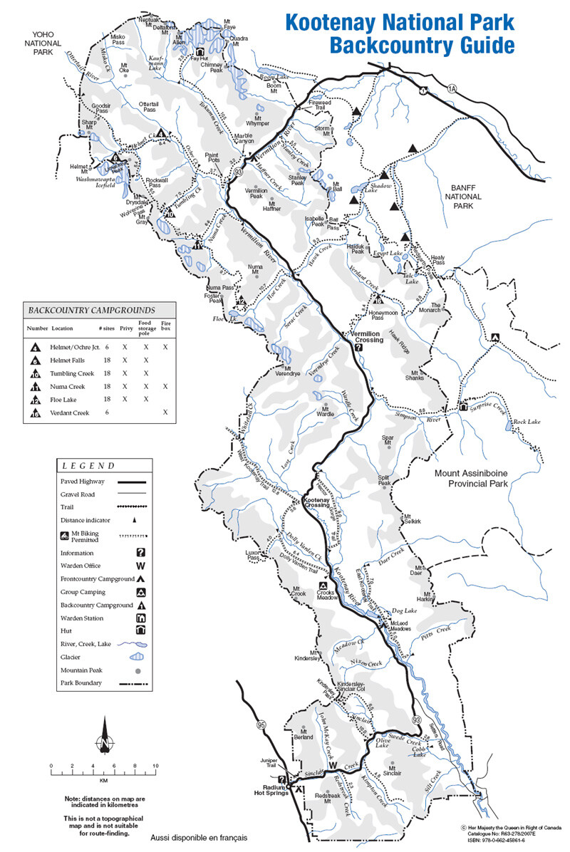
Kootenay Trail and Backcountry Campground Map from Parks Canada.
Distances
Length: 55.6 km
Lowest Elevation: Floe Lake Trailhead, Highway 93S, 1325 m (4350 feet).
Highest Elevation: Numa Pass, 2300 meters (7725 feet).
The Trail
The trail is described here the way we hiked it, which is starting at Paint Pots and ending at Floe Lake Trailhead. We had a shaky forecast for our trip, which came true – it rained every day and every night, with some impressive, and very loud thunderstorms and hail! We managed through no problem, and will definitely be back another year hopefully to hike it in the sunshine. Regardless, unless the forecast calls for heavy snow, consider still doing the trip. If you’re looking for how to hike in rain, read our tips.

Day 1 Paint Pots to Helmet Falls. 13.5 km, 350 m (1150 feet)
If starting from the North, a novice hiker may be worried about carrying their pack at it’s heaviest, at the start of the trip, but that should not be much of a concern. This long distance goes by very quickly as it is largely flat compared to the other days, and no passes are crossed. It is in fact, one of the easiest days, and the least spectacular, with no views except for the very end at Helmet Falls. The view of Helmet falls is one of the first of many surprises to those hiking the Rockwall. It is spectacular!

From the Paint Pots trailhead, cross the Vermillion river – along with many high heeled, fancy handbag-carrying tourists! – and follow the interpretive trail to the richly coloured paint pots. The trail is easy to follow, crossing first the Helmet/Ochre Junction Campground, a perfect place for a lunch stop, rest and to fill up water bottles. Stay left at the junction leading to Marble Canyon and stay right at the junction to Tumbling Creek. About 6 km from the trailhead, you’ll turn left into the Helmet Creek Trail which will lead you to Helmet Falls campground. The junction to Goodsir Pass is the last one you will cross before hitting the campground, only a short ways further.

Day 2 Helmet Falls to Tumbling Creek, 10.7 km, 410 m (1350 feet) gain and 260 m (850 feet) loss to Tumbling Creek Campground
We highly recommend you start the day by taking the side trail that leads you to the base of Helmet falls. Take your backpack and gear for this side trip – the trail branches off from the main trail before you cross the creek to climb up Rockwall Pass. We didn’t get a chance to go up to the waterfalls as we were in pouring rain, and were simply trying to get to our next campsite as quick as possible to avoid the rain.

The trail climbs Rockwall pass quite steadily over some amazing larch forests with views of Helmet falls and extensive wildflower meadows. As you break out of the trees, you see the Rockwall for the first time and get a first look at the scenery which you can admire all the way to Floe Lake. It is an incredible sight. From here to Wolverine Pass, you will have an unobscured and non-stop view of limestone rock to the west, ending at Mount Drysdale to the south. The Washmawapta Icefield is above the Rockwall just out of sight. Between Mount Drysdale and Mount Gray is a break in the Rockwall formation, this is Wolverine Pass. This trail takes you down to the beautiful campsites of Tumbling Creek.

Day 3 Tumbling Creek to Numa Creek, 7.7 km, 335 m (1100 feet) to top of Tumbling Pass and 715 m (2350 feet) loss to Numa Creek Camground
From Tumbling Creek, enjoy views of the dramatic Tumbling Glacier and the lateral moraine. This whole valley was at one point glaciated, and the glacier left it’s mark on the landscape. After making your way up Tumbling Pass, which does not take long, there is a steep descent down to Numa Creek. There are a few creek crossings which can run very high if there is rain. The trail is also quite overgrown in spots which is not a problem when dry; but when raining, like it was for us, the vegetation will quickly make you fully soaked!

The campground at Numa Creek is the quietest of all. Many people choose to skip this campsite and hike from Tumbling to Floe lake in one day, which is very doable. If you do spend the night here you will very likely have it to yourself.

Day 4 Numa Creek to Floe Lake, 10 km, 755 m (2475 feet) to top of Numa Pass and 250 m (825 feet) loss to Floe Lake
The first part of your morning will be spent hiking through the trees, and eventually climbs up and over Numa Pass, the highest point of the Rockwall trail. The scenery is spectacular, and the views from 2300 m (7725 feet) are outstanding. You hike between Foster Peak to the SW and Numa Mountain to the NE. This part of the trail is very exposed to wind and cold weather, and can snow any time of year. We reached the pass just after a big rainstorm, and parties on the pass just an hour before reported snow. The snow didn’t stick around though as the temperatures were well above freezing.

Here you will catch your first glance at Floe Lake. It’s a magical spot, ice floes that calve off the small pocket glacier are often seen in the lake, giving the lake it’s name. It’s the perfect spot for the last night on the trail.

Day 5 Floe Lake out to Highway 93 (Floe Lake Trailhead), 10.7 km, elevation loss 700 m.
The last day is an easy one, with a quick descent down the trail to the Floe Lake Trailhead. An interesting feature of this part of the trial is the burn from the 2003 fires and the gradual forest regeneration that has taken place. During periods of high wind it can be a dangerous spot, with plenty of deadfall and large, hollowed out trees that look like they are precariously perched!

Shorter Trips on the Rockwall
The trail can be shortened in two spots, the Numa Creek and Tumbling Creek Drainages connect to the highway. However, bridges on these trails were damaged in the 2013 floods and have not been fixed yet, and these trails are currently closed.
Longer Trips on the Rockwall
If you’re into a longer backpacking trip, consider linking it with the Goodsir Pass trail. Near Helmet Falls campground, you can take a side trip up to Goodsir pass and simply come down, or you can start the hike in Yoho park (or end on Yoho if you start from the north). After going over Goodsir Pass, you can go down to the highway following the Ottertail River or cutting towards the north to McArthur pass and Lake O’Hara area near Lake Louise.
You can also continue from the south end of the Rockwall and hike up Hawk Creek up to Ball Pass, which is part of the Highline Trail in Banff National Park and heads up to Mount Assiniboine. Simply cross the highway at Floe Lake Trailhead and find the trailhead up to Ball Pass.
Mountain Weather
We had a shaky forecast for our trip, which came true – it rained every day and every night, with some impressive, and very loud thunderstorms and hail! We managed through no problem, and will definitely be back another year hopefully to hike it in the sunshine. Regardless, unless the forecast calls for heavy snow, consider still doing the trip. Rainy forecast? Don’t cancel your trip! You can still hike in the rain and have a good time with some good gear and useful tips. Read our blog about how to prepare for a hike in the rain.


- How to experience the world while isolated at home - April 21, 2020
- How to prevent and treat hypothermia - February 21, 2019
- How to layer with your down jacket - November 28, 2018
We write rarely, but only the best content.
