
How to predict weather in the backcountry
While you’re out there in the backcountry, you’re completely disconnected – which is a good thing. It’s great and very healthy to disconnect from the world once in awhile. But what about when it comes to weather prediction? We rely on our smart phones for access to weather updates, but without the connection, it helps to know how to interpret the weather for signs of change.
It turns out there are a few signs that you can observe to find out if to expect good weather or poor weather. Low pressure systems are the ones associated with bad weather, and high pressure systems are associated with good, clear weather. Luckily there are a few tricks to find out which one is on the way.
The difference between low and high pressure
First of all, it’s important to mention that “weather” is associated with low pressure systems. “Weather” is synonymous for bad weather: rain, low cloud, overcast, snow, wind, and so on. The opposite is good weather which in fact, is no weather at all. Those clear, calm, sunny bluebird days is what you get during a high pressure system.
These tips will help you identify when you can expect a low pressure system.
Generally, you can identify a low pressure system with the clouds that are produced before the actual weather front. A weather front will push up clouds on it’s way through, starting with high altitude clouds first, going to middle, then finishing with low cloud and precipitation. The photo below shows what the sky will show when a low pressure system, or weather front is on the way.
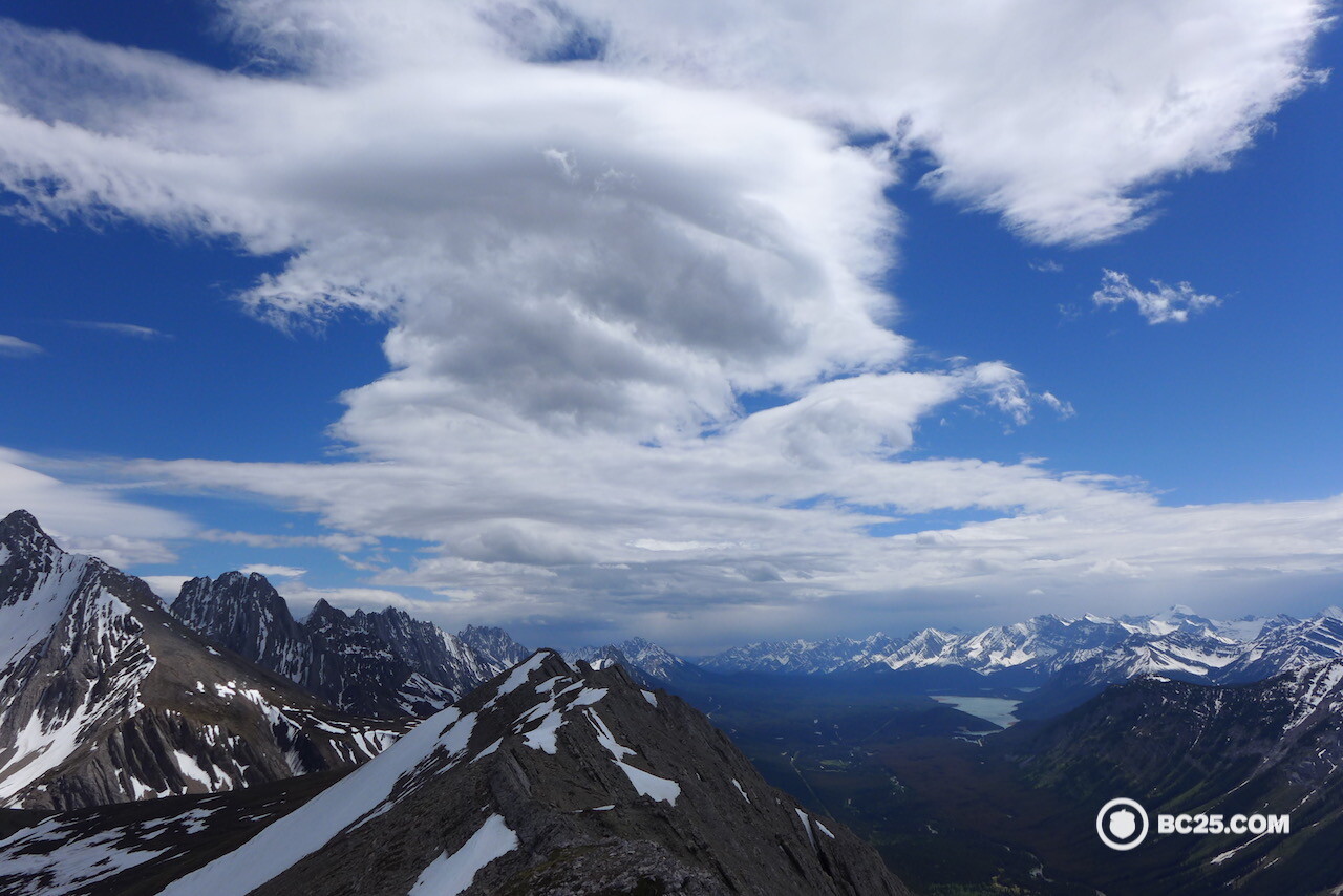
A series of clouds indicates a low pressure system coming. In the distance we can already see dark thunderstorm clouds.
There are four main kinds of weather fronts: the cold front, the warm front, the occluded front the stationary front. The first three are the ones you’ll need to pay the most attention to, since the stationary front doesn’t move very fast and produce very much weather. Read more about weather fronts here.
Indicators to watch for in the backcountry
How do you actually apply this in practice?
Here are some important indicators you can look for while out in the field.
Bad weather
Halo around the sun or moon.

The halo around the sun is formed by high cirrus clouds. The sun is blocked by the mountain in this photo making the ring easy to spot. By the next day, we had overcast conditions and snow!
- This is one of my favourite indicators of bad weather on the way. When you see one of these, expect precipitation in some form (either rain or snow) in the next 12-24 hours. Next time you notice this phenomenon, note it, and expect bad weather in the next day or two. The photo above shoes the halo around a clear sky. This is caused by high altitude cirrus clouds being pushed up by a coming weather front. The day after this photo was taken, low clouds rolled in and it was overcast and snowy.
Cloud movement
- Look at cloud movement. If there are several different layers and types of clouds and they are all moving different directions, this means bad weather is on the way.
Lenticular clouds

Lenticular clouds in the mountains of Kananaskis, Alberta.
- Lenticular clouds are high altitude clouds, typically seen in or close to mountain areas. These signify fast moving air in the upper altitudes, meaning a fast-moving weather front is on it’s way, usually a cold front. In some areas, you’ll see mountain waves, which form on the lee sides of mountains. Avoid going high up in the alpine during mountain wave activity.
Cap clouds
- Cap clouds. These are similar to mountain waves but form right on the mountain top, like a mountain cap or hat! These means there are some seriously strong winds aloft, meaning there is a weather system pushing in.
Cumulous clouds
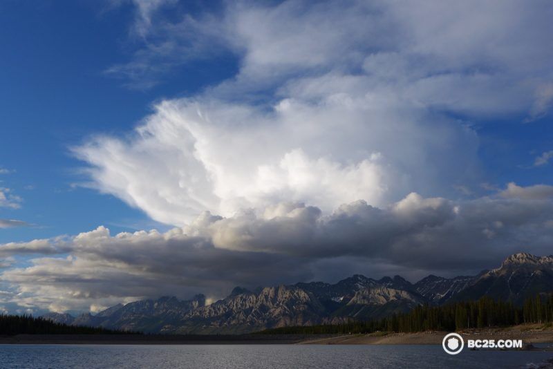
Cumulous clouds can develop into thunderstorm clouds. Here, a fully developed thunderstorm cloud approaches near Canmore, Alberta.
- Cumulous clouds (puffy clouds) are common on summer afternoons. They are formed when thermals, parcels of air heated below from the ground, rise and condense into cloud. These dissipate in the evening when the ground cools. However, if the air mass is unstable, these clouds may develop vertically and form what looks like towers. These are the beginnings of thunderstorms. If you see these clouds building, make sure you’re on your way down a mountain or heading back to camp. Thunderstorms can develop quickly and move fast. The most violent thunderstorms are the ones that move fast.
Campfire smoke
- Watch your campfire smoke if it hovers around ground level, it indicates a low-pressure system is approaching: so rain is on the way.
Seabird activity
- This one is specifically for coastal areas: low flying birds, lack of or low seabird activity on the coast can indicate incoming atmospheric instability: shifting winds and turbulent skies above. They indicate an approaching storm.
Good weather
Wispy clouds
- High altitude, wispy clouds signify good weather to come.
Calm winds
- Calm winds on the surface, especially at night, are a sign of good, stable weather to come. During the day you will always have a bit of wind on those warm summer days due to ground heating and thermals, but by night time these will subside leaving you with a nice, cool night.

Clear sky, calm winds in Hawaii indicate high pressure and good weather ahead.
How else can I get a good weather forecast?
Carry a satellite phone
If you’re unsure, or worried, you might want to consider this as another benefit of carrying a satellite phone: calling someone to get a weather update. We use the Spot satellite phone. These phones require a monthly subscription, and we consider them like we do insurance, in case things go wrong. If we’re worried, we can call our friends to get a weather update.
Altimeter watch
An altimeter watch will alert you to oncoming pressure changes so you can forecast the coming weather yourself. I use the Suunto core, but there are many other options. Check out Madison’s list of outdoor watches, most of which will have this feature. My watch, for example, has a storm alarm to advise of sudden pressure drops, indicating bad weather is on the way or imminent.
- How to experience the world while isolated at home - April 21, 2020
- How to prevent and treat hypothermia - February 21, 2019
- How to layer with your down jacket - November 28, 2018
We write rarely, but only the best content.
