Tonquin Valley and Wates-Gibson Alpine Hut – Trip Report
Tonquin Valley Trip Report
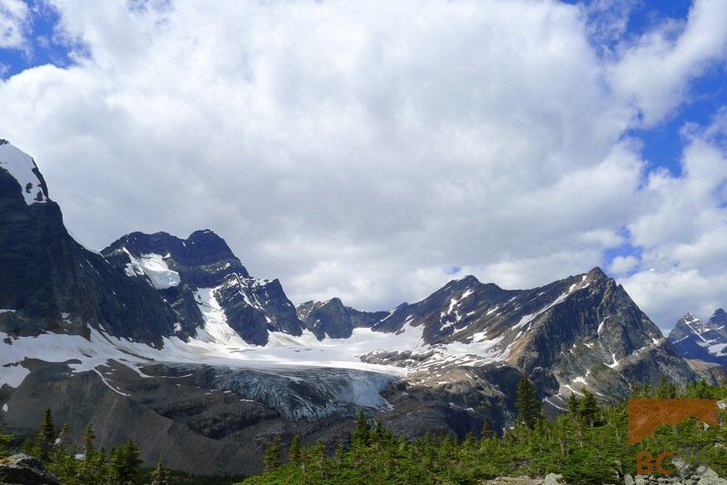
A group of us recently went into the Tonquin Valley near beautiful Jasper, Alberta, in Jasper National Park in July. Like many valleys in and around Jasper, this valley is sweeping and wide: the distances between the peaks are long and low, and the peaks are high in relief due to the low elevation of the valleys beneath them. This is a great place to go if you have several nights or a week to spend – there is lots of technical alpine climbing and mountaineering out here, as well as lots of scenic hiking and scrambling.
Before the caribou closure, this was one of my favorite places to go in the winter to spend New Years. Remote and isolated, there are seldom many people due to the long distance required to get in. Though the backcountry skiing is not superb, there are lots of scenic places you can get to on cross-country or light touring skis. There are also plenty of longer ski tours and some ski mountaineering. Plus the cabin is cozy and warm in the winter, and a great place to pass time in on those long winter nights, especially with good friends.

The Wates-Gibson Alpine Hut
The Alpine Club of Canada has built a cabin in the Tonquin Valley at the head of Outpost Lake. This cabin has been there for 54 years, and the Outpost lake location replaced the cabin in another location. The current standing version of the Wates-Gibson Memorial hut was built in 1959 after two previous structures in different locations were found to be inadequate for various reasons. The location of the hut in front of the lake makes for a convenient water source, and this is particularly important in the winter since you are able to chop a hole in the ice to retrieve water.

The photo below demonstrate the amount of snow that can accumulate. Covering the cabin to the roof!

Access
The hike in to the Wates-Gibson hut is about 18 km on the Astoria River trail. There are about three ways of hiking into the hut – all very long days! The Astoria River Trail is the shortest and most direct at 18 km. There is also the possibility of taking the trail up towards Clitheroe and down Surprise point, which we recommend being done either on the way in or on the way out to take in the scenery. This version is about 4 km longer, but is well worth it on a clear day and to escape the bugs if you end up in the valley in the bug high season.

The other option, albeit very long is through Maccarib Pass (2180 m). We have skied out that way once, and it is a 30 km ski out. To walk in this way would be a very long day, but if access to the Astoria river was closed for some reason then you can break this down into a two-day trip. It’s not a big deal if you are headed to the hut to spend several days, but might not be worth it if it’s just for the weekend.

Common trail closures
The Astoria river trail is closed generally from December to late February or early March to protect the Caribou. The hut is still accessible, but you must go through Maccarib pass in order to access the hut. In the winter this generally must involve an overnight – it would be tough to make it in the 30 km, particularly since you’re climbing up and over a mountain pass with overnight packs, during that time of year when there is at most 7 and a half hours of daylight and the temperatures dip into the -30s regularly. It is pretty safe no say that no one makes it into the cabin during that time period in the winter. If you check the hut log entries you will see a big gap in visits from late November until the spring. If you are the first ones in after the winter, you will have a lot of digging to do as the cabin can easily get buried up to the roof.

Due to the Ghost glacier calving event back in 2012, the Astoria river trail was closed for the rest of that summer and in early spring 2013 for a re-assessment of the glacier to see if there was potential for another chunk of ice to break off. This was done in June and there was found to be no hazard, so the trail re-opened again after another few month break.

The trail down the Astoria river is flat and long. It is wide up until you cross the creek about 7 km down the trail, then it becomes a singletrack trail which can get quite overgrown during the summer months. There was a lot of deadfall on the trail and it crossed lots of marshland, so that meant tons of bugs. There was no stopping for a lunch break – we powered through, eating while walking and dousing ourselves with DEET. As soon as we stopped the bugs would feast on us. Eventually the ramparts come into view and the trail starts to get a bit more scenic for the last few kilometers. The end feels like it stretches on forever for those who are not familiar with the approach. Reaching the cabin is a pretty special moment. A welcome sight, and sanctuary from the mosquitoes!
The sleeping area in the hut is plentiful. It sleeps 30 in summer (24 in winter) and with only six of us we had plenty of room for everyone. Our objectives for the trip were Outpost Peak (2880 m), Thunderbolt Peak (2681 m) and Paragon Peak (3016 m).
Surprise Point
The next day we had an easy half-day, went up to Surprise point to check out some scenery. We hiked up to the backcountry campground then veered left to go up the talus slopes to get a better view of the valley. The mosquitoes followed us up all the way, and high up on the talus as well. The high number of giant spiders and spider webs across huge boulders on the talus was testament to the fact that these spiders often have a lot of bugs to feast on! We hiked down the talus back towards the trail down to Chrome lake, and up again to the cabin.

Thunderbolt Peak
The next day we decided to head up Thunderbolt, taking the trail down again to Chrome lake and veering south towards the Eremite valley. The views of Eremite glacier are spectacluar. There are also numerous other glaciers such as the one on coming between the col of Alcove mountain and Angle peak. As you gain elevation slowly, climbing up an old lateral moraine, the valley opens up and the views become even more impressive. Up here, there are lots of alpine tarns that sit nestled in between low alpine creeping fir and alpine flowers. Up here, the breeze blows briskly and keeps the bugs at bay. It’s a great place to relax.


From here, we followed a gentle shoulder past more alpine tarns and sub-alpine terrain and talus until we reached a notch filled with steep snow. It is here that crossed paths with a grizzly bear! Having a casual conversation with my friend, something made me look over my shoulder and when I did, I couldn’t believe my eyes and had to do a double take – there was a medium-sized grizzly bear walking the other direction, passing within about 8 meters of us. He was walking the other direction and seemed not bothered at all by our presence. I announced this fact very causually to my friends, after which we walked up the talus slope above as as quickly as we could and made lots of noise so the bear goes the other way. He took his time. Glanced up at us, wandered a bit, sad down and scratched his head with his massive paw. We watched him for awhile and eventually lost sight of him. He went the direction we came from, which was to be our return route. We would have to bushwack down to the trail and shortcut a bit to avoid going the same way he went. We wanted to give him a wide berth. Below are a few fuzzy pictures we took in a panic, after making sure that he was definitely leaving the area!


From this point, scramble up steep talus for a bit, then the angle eases off. You’re on a talus ridge for awhile and then you reach a large snow bowl, where the ridge becomes blocky and more hands on rock scrambling. The way to the summit is easy and enjoyable and there is no exposure. The view from the summit is amazing! The rest of thunderbolt is composed of large, angled slabs that look like sawbacks, they are very sharp and dramatic. The west side of Mount Edith Cavell is also visible from here.
The photo below shows the view from the summit. The wide Tonquin valley yawns before you and if you look very closely at the tiny alpine lake in the left side, the hut appears as a small dot above the lake. It is hard to see, but unmistakable when you are on the summit of Thunderbolt.

The way down to the trail involved a bit of bushwacking but wasn’t as bad as we thought it would be, the worst part was definitely the mosquitoes which were happy to have us with them in the forest. It was evening by the time we got to Chrome lake again, and we were back in the cabin at about 7 pm, so the whole trip took us about 8 hours. We estimate we hiked close to 20 km that day, and gained about 1000 meters (due to the loss going down to Chrome Lake). It was a lot of walking but an amazing outing – well worth it.

The next day a couple of us had planned the exposed ridge of Parapet peak (I) but the weather was forecast to turn stormy the next day and over the next few days so we elected to hike out a day earlier than planned. Outpost Peak would also have to wait for next time.


We hiked out the next day, the long way going towards surprise point and Clitheroe where we enjoyed views of the ramparts much of the way. The trail is enjoyable, wide and well-traveled. The hike out took us approximately six hours including rest stops. There are lots of opportunities to collect water here as there was still lots of snowmelt from high above and the streams were running high. The last part of the trail feels like it takes the longest, but before we knew it we were back at our vehicles. What an amazing time!

Tips for heading into the Tonquin Valley
- Be prepared for lots of walking, the hut itself is far and the distances from peaks are long
- Consider doing this trip in late August, when you can still take advantage of mountaineering or alpine climbing objectives while the bugs are gone
- The hut is deluxe, so bring lots of gourmet food! It is well equipped with plenty of propane stoves, utensils, baking pans and even a working oven
- Consider spending a good amount of time here – we recommend a 3 night minimum but if you can stay a week you will be able to do tons of exploring in this seldom-visited area
Where to Stay before or after your trip
We recommend staying in Jasper at one of the nearby campgrounds or at a hotel.


- How to experience the world while isolated at home - April 21, 2020
- How to prevent and treat hypothermia - February 21, 2019
- How to layer with your down jacket - November 28, 2018
We write rarely, but only the best content.
