Backpacking the West Coast Trail: Our trip report
Our Trip
Thinking of backpacking the West Coast Trail? If you’ve read our tips and advice report, including when to go, transportation and trip logistics, now find out about our experience on the trail.
We started in the afternoon of May 13, starting with a leisurely drive from Victoria, making it in time to grab lunch in Port Renfrew (YUM) before the 1 pm orientation. We had a delicious lunch at Coastal Kitchen Cafe. You must take the orientation prior to starting the trail, and after the local natives will take you across Gordon River to the start of the south trailhead. Gordon river is only passable by boat. After the orientation we set off to pack the rest of our things and wait for the taxi to take us across Gordon River to the south end of the trail. We shared the boat with two other hikers.

Day 1: Gordon River to Thrasher Cove: 6 km
Because we started in the afternoon (the boat took us over to the trailhead at around 2:30 pm) we had planned our first camp at Thrasher Cove, which is only 6 km away, including a 1 km hike down to the beach. The next campground is at Camper Bay, another 8 km away. With a travel time as slow as 1 km/hour on some parts of the trial, to venture past Thrasher Cove at that time means hiking and setting up camp in the dark. No fun! It took us 4 hours to hike those 6 km, and the last kilometer down to the campground and beach involves numerous ladders and steep hiking on some slippery terrain.

Thrasher Cove is a nice, small beach with a stream for water and a composting outhouse. Take care not to put your tent too far out, as high tide can easily flood your tent. The next day we had planned to hike to as far as we could. We were in a bit of a time crunch on this trip, we only had four nights on the trail (as opposed to the six nights we had on a previous trip) because we wanted to meet with some good friends in Strathcona Park, friends we rarely see before we had to leave Vancouver Island.

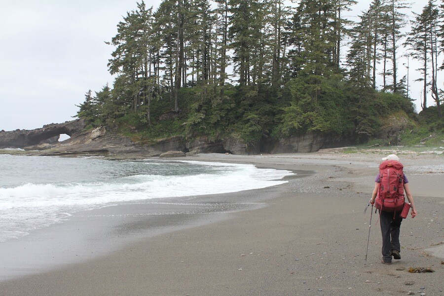
Day 2: Thrasher Cove to Cullite Cove: 12 km
On day two, we were mentally prepared for a tougher trail but also thinking that there is not THAT much more tough hiking anymore, we pushed on, hiking the beach from Thrasher Cove to Owen Point, where you can pass at tides lower than 6 feet / 1.8 meters. The hiking here is nice, because you’re on a beach and have great views, but it’s slow going due to all the large boulders you have to climb up and over. It’s slow hiking for awhile then gets a bit better, and before kilometer 65, the route spits you out back into the rainforest again due to an impassable headland.

This section of the route is very slow and we had a small break at Camper Bay, then pushed on. The next 4.5 km took several hours to walk! Finally, after a muddy and long 9 hour day, we descended on our camp at Cullite Cove. We had only covered 12 km of trail that day! Cullite Cove is a beautiful spot with a pebbly beach, tucked in two massive headlands and a stream. The ocean break echoes in between the Cove, and here, you can sit several meters away from people and not hear what they are saying, the surf is that loud.

Day 3: Cullite Cove to Cribs Creek: 16 km
So the tough times are over, I thought – trail is easier from here? Not yet! Still lots of bogs, ladders, mud to deal with. It’s slow going yet again. Mentally discouraged, we trudge on, past Logan Creek and Adrenaline Creek, taking the numerous ladders down and back up. After passing Walbran Creek, via cable car things get a whole lot easier. The trail, still muddy and boggy, starts going a little bit faster. You don’t start covering ground quickly until you down climb many ladders and pop out on the beach just past Vancouver Point, around kilometer 51 or so.

At this point, we had hiked only 24 km, and this had taken us two and a half days, and a total of about 21 hours. We wanted to be off the trail in two days, yet still had 51 km of hiking to do! Luckily, this is where the trail gets a lot easier, you can relax and enjoy, and cover some ground very very quickly. The beach hiking after this is easy and enjoyable. After a short distance (about 5 km, which does not take very long) you will come upon Chez Moniques, near the Carmanah lighthouse, where the friendly staff will be happy to sell you snacks, beer, pop and even a burger. It’s paradise found on the beach! Never has a beer tasted so good.

We relax for a little while then carry on to our campsite, at Cribs Creek, only another 3.5 km away. The Cribs Creek campground is very spacious with a lovely sand beach. After a third hard day of hiking, we stop for the night after 9 and a half hours of hiking and 16 km covered that day. We have another 41 km to go and only one and a half day to do it. We had already hiked 34 km of the trail.

Day 4: Cribs Creek to Tsocowis Creek: 26 km
The next day is another beautiful day of mostly beach hiking, and we don’t even see a soul all day until our crossing at Nitinat Narrows. This section is beautiful walking with not a ton of up and down, but with lots of scenic, flat beach, and easy forest hiking. At the Nitinat crossing, you can buy some snacks and pop from the locals, and they will take you across the channel. We have walked about 10 km.

The next part of the trail goes fast, but we are in a hurry so don’t have a lot of time to savour it and enjoy it. Today will be our biggest mileage day because we have to catch the bus at Pachena Bay to get back to our vehicle at 1 pm. We finally make it down to our camp at kilometer 16.5, at Tsocowis Creek, after 26 km of walking in 10.5 hours. This is a nice, small campground with a beautiful waterfall. It’s a sandy beach, and there aren’t a ton of good spots for your tent because of the sloping beach. We collapse in our tents. We only have 16 km to go – but we have to hike it all in the morning.Our bus leaves at 1 pm!

Day 5: Tsocowis Creek to Pachena Bay: 16 km
The next morning we wake up early and begin walking the beach instead of the forest. After only about 30 minutes of walking, we come upon a large black bear blocking our way. We haven’t seen anyone for two days, and suddenly feel quite alone on the trail. We make noise and the bear, about 800 m away, looks in our direction. Unperturbed, he walks back and forth along the beach, minding his business. Then he starts walking in our direction. So, we check our map and luckily, there is a trail we can use to bypass the beach and the bear.

The trail is full of bear scat, and we make lots of noise. Once we come out at around kilometer 14, we look back around the bend and see the bear is still where we left him. However, when he sees us he starts walking in our direction, so we start walking faster than ever before! As we get further away from where we came off the forest trail, about 500 meters or so, the bear pops around the corner. It seems like he is interested in us or just being territorial of the beach he’s exploring. Our walk turns into a light jog now, and we are impatient to get to the beach at kilometer 12, where we expect to find some people camping. Unlucky for us, there is no one there.

It’s a lonely feeling, just the two of us and a bear following us around. We have no time to linger, and with the clock ticking we zoom along the trail. It’s already 11:00 and we only have two hours to cover 12 km. The trail is fast and easy at this point but there is still a lot of up and down, and about 6 very long ladders at the end, which makes your heart sink when you are in that kind of rush! Running along the trail we could hear the sea loins roaring off the haul out rocks past Pachena lighthouse. They are well worth a look!

We manage to make it out in time for the bus, which is even late, giving us time to remove our nasty hiking boots and change into dry clothes for the long bus ride back to Gordon River. At around 5 pm, we are back at the ranger’s station, where we make a report of the bear sighting and promptly head for a much deserved dinner and beer at the Coastal Café.

Phew! The trail is grueling at times and very physically demanding. At times you will wonder why you signed up for it, but will find it incredibly rewarding and will probably want to do it again. This was our second time on the trail. Our one mistake this time was that we didn’t give ourselves enough time to enjoy it, we had really long hiking days, hiking often 8-10 hours a day, with little to no down time. An extra day really would have made the difference, especially on the very enjoyable section North of Walbran Creek. More time will allow you to have longer evenings, which are extremely enjoyable spent out on the beaches, time for fishing or exploring.

Highlights
The highlights of the trail are definitely the beach camping. One of the nicest campgrounds is at Tsusiat Falls, with a beautiful waterfall as a backdrop. The Michigan creek, Cribs, Carmanah campgrounds are also highlights. The Chez Monique café is a highlight – beer never tasted so good – as well as the views from the cliffs at Valentia Bluffs are amazing.

Hiking Tips
Rain Gear
We were lucky to hike the trail during a period of steady high pressure, hence we had sun and warm temperatures all week. However, most of the time it’s not the case, so adequate rain protection is essential. Aside from a good tent that can resist wind and rain, and heavy coastal storms, a backpack rain cover is recommended. These can be purchased at Mountain Equipment Co-op or any other outdoor retailer for about $15 or so, and is well worth the cost. You will be happy you brought it. You will be able to hike in the rain without worrying about your gear getting wet. There really is nothing worse than a wet sleeping bag, and once things get wet on the coast – they don’t really properly dry. And don’t forget a good rain jacket and rain pants.
Good Food
Bring some food to spoil yourself: chocolate, cheese, sausages, whatever you find satisfying and savoury. You will burn lots of calories and will need to replenish! That being said, don’t over-weigh your pack, as carrying a very heavy pack can spoil your trip. Be smart about what you take.
Water Filter or other way of purifying water
A water filter or some way to purify water is recommended. We didn’t take one, and luckily didn’t become sick. We made sure to take water from creeks where there was no trail above so no contamination. However we did take a risk, and should have taken precautions.
Camera
Take a camera, and take lots of pictures. You will appreciate having the memories. Make sure not to always rush but to enjoy your surroundings.
Good Boots, worn in
Good backpacking or hiking boots are a must. Preferably a boot with goretex as your boots will get wet, you’ll be stepping into deep mud at times. You’ll also want them to have good grips. That being said, good socks and plenty of socks to change into are important – particularly socks that dry fast. And a blister care kit just in case.
Time
You can certainly do the trail as quick as possible, and it’s even been done in a day – several times. So why rush to try to beat any records? Do the trail at least once in a slow pace, where you can really take in the natural surroundings and appreciate the wild ocean. The more time you take to enjoy the trip, the more you will get out of it.
Enjoy!
There is really nothing like the West Coast Trail, it is highly recommended and it will leave an impression. The mystic beaches, magical rainforests, the sea life and wildlife and ocean scapes will leave you mesmerized. It’s physically and mentally exhausting at times but once you venture on it once you’ll be thinking about coming back to it again one day.
If you haven’t already read our trip advice report, including history, when to go/season, transportation and logistics and loads of other advice, please read it here.


- How to experience the world while isolated at home - April 21, 2020
- How to prevent and treat hypothermia - February 21, 2019
- How to layer with your down jacket - November 28, 2018
We write rarely, but only the best content.
